Table of Contents
- History of Nellis Range, Nevada Test Site and the Groom Lake Facility
- Maps of Nevada and Southern Nevada
- Nellis Range, Nevada Test Site and Nellis Air Force Base
- Sites Of Interest
- Viewing Directions
- Maps
Groom Lake Facility (Area 51)
- Area 51 & Related Sites of Interest
- Viewing directions
- Map
Nearby Locations of Interest
- Zion National Park
- Valley of Fire State Park
- Hoover Dam
Appendices
 |
History of Nellis Range, Nevada Test Site and the Groom Lake Facility |
|
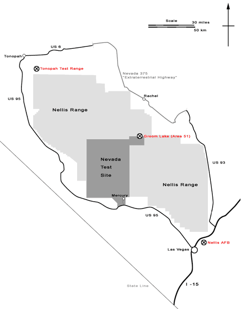
Nellis Range
Since the beginning days of the Cold War, the United States Military and other government agencies have been active on the lands north and west of Las Vegas. The beginning of military land use was in 1941, when President Roosevelt signed 5,000 square miles of land in the Nevada Desert to the War Department, who would initially use it as a gunnery range. This land stretched from Las Vegas in the southwest to Tonopah in the north; both sites housed Army Air Force (later Air Force) fields. The Nellis Range is slightly smaller than the state of Connecticut.
Nevada Test Site
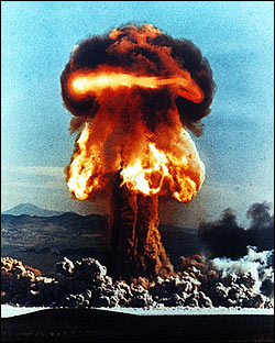
After the destruction of Hiroshima and Nagasaki and tests of atomic weapons in the south Pacific, the Atomic Energy Commission (AEC) determined that they needed a closer range for further testing of the devices. In 1952, a public land order set aside 680 square miles of the newly renamed Nellis Range for the atmospheric testing of low-yield atomic devices. In all, 119 atmospheric tests were conducted, many on Frenchman and Yucca flats [see map].
The largest above-ground test was codenamed Hood with a yield of approximately 74 kilotons or 74 thousand tons of TNT. When the Limited Test Ban treaty of 1962 went into effect, the testing went underground. From 1962-1992, around 800 below-ground tests of nuclear weapons were done at the test site, pockmarking the landscape [see graphic below]. The largest of these were in excess of 100 kilotons and formed craters several hundred feet deep.
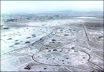 U.S. Department of Energy photograph
Not all US nuclear tests were conducted inside the Test Range, and of particular interest is a crater left over from 'Project Faultless' in south-central Nevada that is not on restricted land. You can visit it and see the visible depression the underground test left behind. See the section devoted to Other Locations of Interest.
Groom Lake Facility
In April, 1955, the CIA needed a remote location to flight-test their new joint venture with the Air Force, the U2. They settled on a dry lakebed just west of the Groom Range nestled on the outskirts of the Nevada Test Site. With $800,000, an airstrip, control towers and hangers were built on the southwest corner of the lake. The Lockheed company test pilots that used the base nicknamed it "Paradise Ranch".
When a U-2 was shot down on a reconnaisance overflight of the Soviet Union, its successor was already in development at "Dreamland" (as the airspace around the base is called by pilots). The SR-71 Blackbird was an aircraft designed to fly at Mach-3 at the edge of the atmosphere, well beyond the reach of Soviet missles. After housing the development and flight testing of the SR-71 (also known as the A-12), Dreamland began to diversify its operations. An operation to reverse-engineer foreign aircraft was began in 1967. The precursors to the F-117A Stealth Fighter began flight-testing in the late 1970s and was home to the aircraft until it was unveiled to the public in 1990.
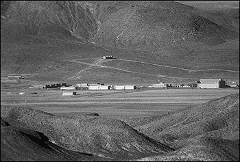
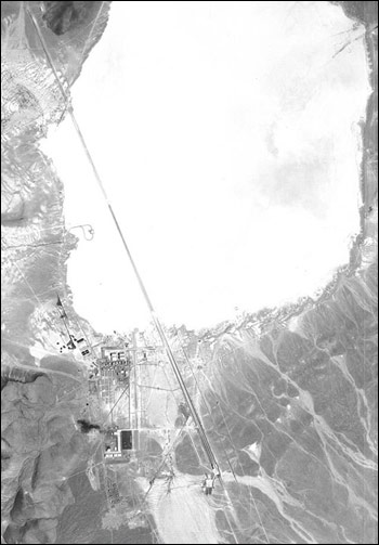 1968 U.S.G.S. Photograph of Groom Lake
The Groom Lake Facility, which is located in Area 51 of the Nellis Range, began to gain widespread public noteriety in 1989. Bob Lazar, who claimed to be a physicist and to have worked at a base near Area 51 reverse engineering alien spacecraft, appeared in a series of interviews on a local Las Vegas television station. He led 'expeditions' to a mailbox (the now-famous 'Black Mailbox') on a highway outside of the Range. From there, many people witnessed spectacular aerial shows of lights and other craft that some people claimed were alien in origin.
Soon, Area 51 became a media sensation. It appeared in The New York Times, Popular Science, network nightly news programs, and many other forms of media. The Little A'Lee'Inn (pronounced alien) became a popular tourist destination because of its central location on that same stretch of highway north of the Black Mailbox. The base was featured in the movie Independence Day, though in a way that was anything but accurate.
Due to all this popularity, the Air Force seized several thousand acres and two popular vantage points around the base in April 1995. Since then, the hype has died down. You can still visit the all the places mentioned above (outside the restricted line, that is); they continue draw visitors daily.
|
|
Maps of Nevada and Southern Nevada |
|
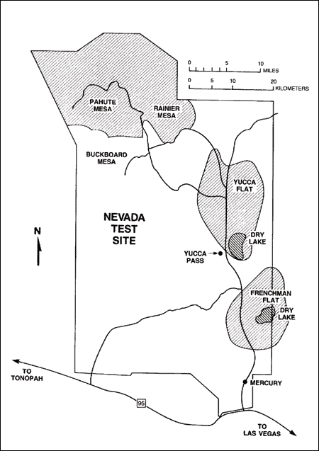
Map #1: Nevada State Map with Inset Outline
 Map #2: Inset Map - Relevant Sites and Roads
Las Vegas to Tonopah
|
|
Nellis Range, Nevada Test Site and Nellis Air Force Base - Sites of Interest |
|
- Nellis Air Force Base
- Nevada Test Site
- Frenchman Flat
- Sedan Crater
- Mercury
- Yucca Mountain
- Tonopah Test Range
Nellis Air Force Base
Headquarters to the Air Force's Air Warfare Center and the USAF Fighter Weapons School, Nellis is the home to some of our most advanced aircraft and pilot training facilities.
Area 2
Once known as 'Lake Mead Base', this complex to the East of Nellis AFB is a storehouse for conventional and non-conventional (nuclear) weapons. It is surrounded by a high electrified fence and it comprised of a series of earthen bunkers in addition to various other buildings and dorms. It is also the home the Nellis Federal Prison Camp.
Nevada Test Site
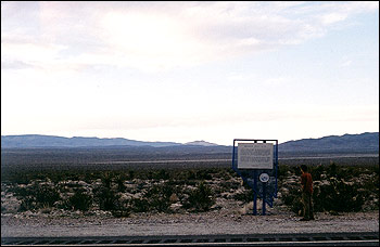
NTS Sign on US-95 outside of Mercury, NV
(For full text, see footnote.)
Home to our nation's continental nuclear testing for 30 years, the NTS has a fascinating history and many major landmarks.
Frenchman Flat
 If you've ever seen a film of a nuclear weapons test with soldiers hunkered down in trenches, or homes, cars, or trees being blasted away, this is where it happened. Dozens of so-called 'atmospheric' tests were conducted here to demonstrate the viability of certain methods or structures in the event of nuclear war. Only relatively low-yield atomic weapons were tested above ground on Frenchman Flat and the nearby Yucca Flat. High-yield weapons like the thermonuclear bombs were still tested in the South Pacific because they were too large and hazardous for continental testing.
To the right is an example of one of the atmospheric 'shots' as they were called. This shot was a test on Frenchman Flat of an experimental weapon fired from an artillery shell, only 28 centimeters in diameter. It was the only test of an artillery shell device.
U.S. Department of Energy Photograph
Sedan Crater
In one of largest underground tests in US history, a 1-Megaton yield weapon was placed 630 feet down on Yucca Flat and detonated. It launched massive amounts of debris into the air and formed the largest crater at the NTS.
Sedan was part of the 'Plowshare' program, an effort to explore possible peaceful uses of nuclear devices. (Among these would be excavation, drilling, etc.)
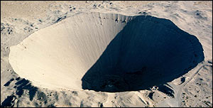
U.S. Department of Energy Photograph
Mercury, the second largest town in Lincoln county, is the DOE's base of operations for the Nevada Test Site. There is not much to see here except some operations buildings and drab government housing.
Yucca Mountain
Yucca Mountain is the future site of the nation's nuclear waste depository. Feasibility tests have been ongoing to determine if the mountain is a stable, suitable site to hold these wastes from nuclear plants, and industrial and medical byproducts. It is located near Yucca flat inside the Test Site.
Tonopah Test Range
Located Southeast of the town of Tonopah and at the northwestern edge of the Nellis Range, the Tonopah Test Range is a testing ground for new aircraft and concepts. Much like the Groom Lake Facility, it provided a home to the F-117A Stealth Fighter in the later years of its development. The TTR includes an airbase as well as radar testing grounds, and security is less intense than that at Groom Lake. You can see the airbase from vantage points off of US-6, and as long as you stay outside the fence you should be okay.
*NTS Sign text:
Testing of devices for defense and for peaceful uses of nuclear explosvies is conducted here. The nation's principal nuclear explosives testing laboratory is located within this 1,350 square miles, geologically complex, area in the isolated valleys of Jackass, Yucca, and Frenchman flats. Selected as an on-continent test site in 1950, the first test took place on frechman flat in January, 1951.
Archelogical studies of the NTS area have revealed continuous occupation by prehistoric man from about 9,500 years ago. Several prehistoric cultures are represented. The last aboriginal group to occupy the site was the Southern Paiute who foraged plat foods in season and occupated the area until the coming of the pioneers.
|
|
Nellis Range, Nevada Test Site and Nellis Air Force Base - Viewing Directions |
|
Direct viewing of these sites is extremely difficult, because they are all in restricted military areas. However, there are a handful of vantage points and tours listed below that will let you see a good deal of the Range and the sites that lie inside it.
- Nellis Air Force Base
- DOE Nevada Test Site Tour
Nellis Air Force Base
Nellis Air Force Base is one of the most active in the country, hosting wargames for the US as well as other allied nations. These wargames frequently light up the night skies over Area 51 with dogfights, flares and afterburners. In addition to the many official tours available at the base, which is the home of the Thunderbirds (the Air Force's aerial display team), there is one particularly fun and easy-to-access vantage point which allows unobstructed views of the base and its flight operations.
A dirt parking lot sits at the bases's perimeter gate, just beyond the end of the dual runways. You can park and watch many different types of aircraft take off and land just above your head. It can be entertaining for several hours if you come prepared (with lawn chairs and drinks). Area 2, described in 'sites of interest', is clearly visible as it sprawls off to the East.
Take Las Vegas Boulevard North past the Nellis's Main Gates. (You can stay on Las Vegas all the way from the strip, but taking I-15 to Craig Rd., then East to Las Vegas is much faster.) Stay North until the fence that is running alongside the road veers East. There will be a telephone pole and a dirt turn-off. Follow the dirt turn-off back until you come to a wide dirt parking lot on the right next to the fence.
DOE Nevada Test Site Tour
The only way the public is allowed to see any portion of the Nevada Test Site firsthand is through a tour that the Department of Energy (DOE) offers. Unfortunately, they occur on a monthly basis so any long-distance trips will have to be planned around them if you want to visit the NTS.
DOE/NV - Nevada Test Site Tours is the official site of these tours, providing location, contact and security information. Below is an excerpt from the page:
Points of Interest
- Mercury is the main base camp for the Test Site and the second largest community in Nye County.
- Frenchman Flat, where on January 27, 1951, the first atmospheric nuclear test on the Nevada Test Site, ABLE, took place. Thirteen subsequent atmospheric nuclear tests were conducted at the site between 1951 and 1962.
- Hazardous Material Spill Center is used by the chemical and petroleum industry, and government agencies to test spill dispersion, and mitigation and cleanup procedures.
- Low Level Radioactive Waste Management Site for the disposal of radioactive waste from the dismantlement and cleanup of DOE and DoD�s weapons production complex.
- Control Point 1 was the command post used for conducting nuclear tests. Today, it plays an important role supporting other Test Site missions.
- News Nob was a viewpoint from which journalists and visiting dignitaries witnessed atmospheric tests.
- Sedan was a cratering experiment as part of the Plowshare program - the peaceful uses of nuclear explosives. The 104-kiloton nuclear device explosion displaced about 12 million tons of earth, creating a crater 1,280 feet in diameter and 320 feet deep.
No cameras, tape recorders, or any note-taking devices are allowed. An Unofficial Test Site page gives a little more detail, with some pictures. Many people have taken the tour, so there are good descriptions of what the tour is actually like. Here are a small sample:
- A tour of the Test Site / Paul McGinnis
- Tour of The Test Site / DOE
There are other ways to see the test site, since plenty has been published about it.
- Excerpt from the Center for Land Use's Publication about NTS
- Ghost of the Atom - NTS B&W Photography
- The Official NTS Home Page - With Images
|
|
Nellis Range, Nevada Test Site and Nellis Air Force Base - Sites of Interest |
|
Nellis Range
See Map #2.
Nevada Test Site
From the National Cancer Institute's Study on The Health Effects of NTS
|
|
Groom Lake Facility - Area 51 & Related Sites of Interest |
|
- Groom Lake Facility
- Operations
- Security
- Restricted Viewpoints
- Groom Lake Road
- The Extraterrestrial Highway
- Rachel, Nevada
- Black Mailbox
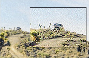
Groom Lake Facility
Hanger 18, the base's largest, is at right
Until 1994, the Federal Government would not admit that this base, partially pictured above, even existed. Even today the Air Force, which owns and operates the facility, refuses to discuss what goes on there. Couple this with a decades-old tradition of UFO-related Goverment conspiracies and strange lights and vehicles in the sky above Area 51, a phenomenon was born.
Rumors, speculation and hype ran rampant in the news, TV shows, movies, and the Internet. This desolate spot in the Nevada desert became an overnight mecca for UFO-faithful, military afficianados and pop-culture buffs alike.
Operations
Area 51 is a flight test center for exotic and prototype aircraft, operated by the US Air Force. Although it has been suggested that Area 51 has been shut down or moved elsewhere, recent additions such as a lengthened runway seem to indicate otherwise. (The newly lengthened runway is the longest in the world at 30,000 feet.) Flights of unmarked 737s still fly personel from Las Vegas on a regular basis, and shuttle vans or buses can be seen traveling in and out of the base. (For the curious, it passes along Groom Lake Road on the way to Ash Springs at around 4-4:15.) Even with the military cuts seen in the last few years, it still seems that Area 51 has plenty of development work to do.
Security
The security operations at Area 51 are almost legendary, and the guards that patrol the entrances and adjacent grounds have been given the nickname 'Cammo Dudes' for the desert cammoflage they occaisionally wear. At any given time, one or more sets of Cammo Dudes will be parked on lookout spots above the entrance to the restricted area on Groom Lake Road. They had long used white Jeep Cherokees but recently have switched to white Ford F150s.
Taken March 14, 2001
Security, as well as the rugged desert terrain, has effectively and consistently stopped any would-be Area 51 observers from wandering around the restricted zone. If you feel the need to get out and look around, be sure to always have an eye on the sticks with the orange balls on top - they mark the border, but not very well. There are very few fences anywhere along the border of the restricted zone. There are sensors on Groom Lake Road and at all places roads enter the restricted zone, so it is very difficult to get close undetected.
Restricted Viewpoints
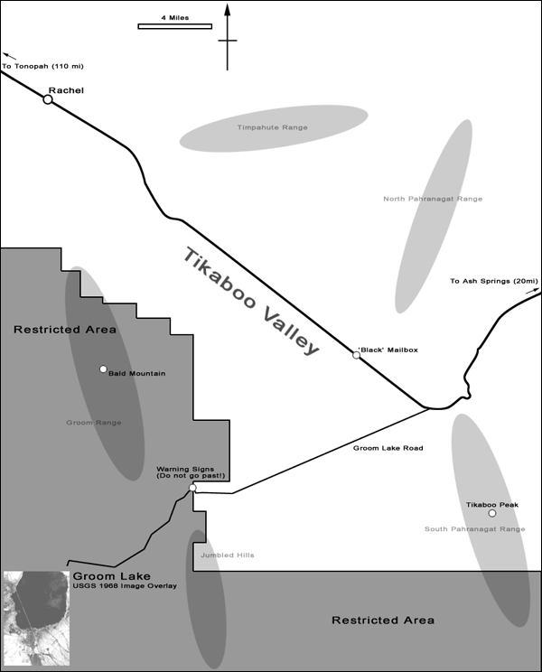
Two very popular vantage points to look down onto the base at Groom Lake were closed down April 10, 1995 during some of the most intense public curiosity about the base. They allowed an unobstructed view from the remarkably short distance of 10-12 miles. White Sides and Freedom Ridge were acquired from the Bureau of Land Management in a controversial move. You can still see White Sides while traveling down Groom Lake Road. It is the small peak with white sides directly north of the road about 3 miles before the point the road enters the restricted zone. Freedom Ridge is on the South side of the road. Both will now get you detained and fined for trying to reach them.
Groom Lake Road
The Extraterrestrial Highway
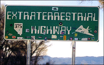
Dedicated on Apr 17, 1996, Nevada Highway 375 became known as The Extraterrestrial Highway. This was a move by Nevada's governor to boost tourism and get some publicity. Signs are now posted along the length of the highway. Below is the sign at the entrance to 375 in Ash Springs. A sign in Rachel has a more elaborate design featuring saucer-shaped UFOs.
Rachel, Nevada
Originally a base for mining operations in the hills to the North and East of the town, Rachel is still little more than a collection of mobile homes next to the world's most famous secret base. There are, however, two notable places to stop in Rachel which have made it a must-stop for anyone visiting Area 51: The Little A'Le'Inn and the Area 51 Research Center.
A comprehensive history of Rachel is online that covers the early days of a mining town to 'UFO capital'. It is a fascinating read if you have a few spare minutes and an interest in what life is like in this part of the country.
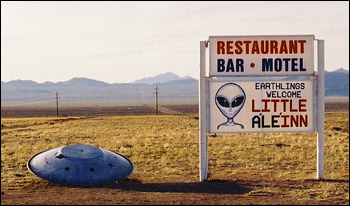
- Little A'Le'Inn
Originally The Rachel Bar and Grill, the The Little A'Le'Inn was renamed in 1990 after Bob Lazar appeared and the area started receiving large numbers of visitors. You can still stop and eat though the selection has been disappointing small since their deep-frier was shut down for fire-code violations. Of more interest is the number of photographs of military flares ('UFO's), classic UFO shots, and a large panorama of the base from White Sides before it was closed.
The 'Inn does have plenty of merchandise for you to peruse and you will probably see the owners, Joe and Pat Travis. You might catch Pat running the new mail-order business or Joe drinking at the bar by the window.
- Area 51 Research Center
On the other side of Rachel from the inn there is a yellow mobile home which houses the Area 51 Research Center. Originally founded by Glenn Campbell, a larger-than-life figure in the history of Area 51 (see Other Resources), it is now operated by others like Donald Emory and his father. It is open most all the time, but you should see the web site to make sure it won't be closed when you are in Rachel.
The Research Center is packed with books, posters, maps, models, and almost everything else Area 51 related. Be sure to add a thumb-tack to the map of visitor's homes. The US map was virtually covered, as was a surprising amount of the world map. (There was a visitor from Mongolia!) This is a good place to hear about the latest goings-on, with a decidedly more rational bent than the Little A'Le'Inn. Joe Travis reportedly has sent many past the warning signs on Groom Lake Road to their detainment and $600 fine.
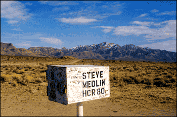
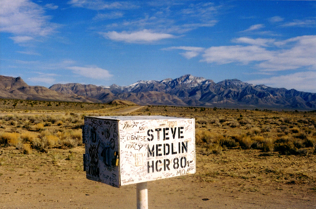
The Black Mailbox
Originally black, this mailbox was the place that Bob Lazar led groups to view the strange aerial displays above Area 51 in the early 1990s. It belongs to the sole inhabitents of the Tikaboo Valley, a rancher and his family by the name of Medlin. Like the Statue of Liberty for visitors to New York, it has attracted many visitors to Area 51. Often, they will leave hastily-scratched messages which are amusing and revealing. A high-resolution version of the below picture is available, with Badger Mountain and Tikaboo Peak in the background.
|
|
Groom Lake Facility - Viewing directions |
|
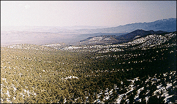
Area 51 has not maintained its 'top secret' status by being easily accessible. However, until 1995 it was relatively easy to see from the viewpoints discussed in Area 51 & Related Sites of Interest. After the Air Force sucessfully obtained the land, only a very small number of places to view the base were left. The closest and most popular of these is Tikaboo Peak (rhymes with 'Peek-a-boo').
- Tikaboo Peak
- Getting There
- View from Top
- Other Viewpoints
Tikaboo Peak
Other Viewpoints
There is only one other terrestrial viewpoint of Groom Lake, from Mt. Reville about 30 miles north-northwest of Rachel. However, you can legally fly closer to Groom Lake than you can get at Tikaboo, for a much better vantage point. Certain commercial airline routes come very close the Northern side of the Nellis Range, and Area 51 is visible if you sit on the correct side of the aircraft on a cloudless day. Some of these routes may include Phoenix - San Franciso or Phoenix - Portland.
If none of these viewing options sound particularly appealing, there are always plenty of images available on the Internet. See the Other Resources page.
|
|
Groom Lake Facility (Area 51) - Region Map |
|
|
|
|
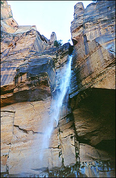
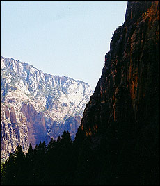
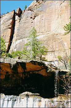
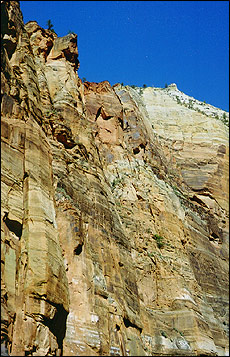
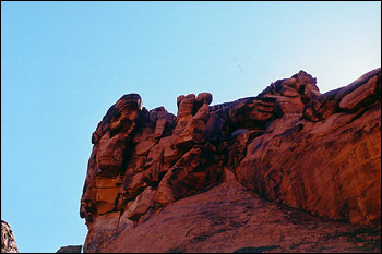
Nearby Locations of Interest - Zion National Park |
|
Zion National Park, named by early Mormon visitors, contains many large canyons and steep cliffs with colorful bands of exposed rocks. The scenery is truly spectacular, and along with the rocks there are many streams and waterfalls to enjoy. Even several days would be insufficient time to fully take in the sights - don't feel too bad if you don't have longer.
Zion is a zoo in the summer, when traffic jams occur often. Do not go between April and September; it's best to avoid the crowds, cars, and the heat. All 3 Emerald Pools are worth the relatively short walk, as are many of the other short hikes. A small fast-food restaurant is in the middle of the park, and good for a quick meal.
The North Rim of the Grand Canyon is less than a two-hour drive from the East Entrance, but it is snowbound through April.
|
|
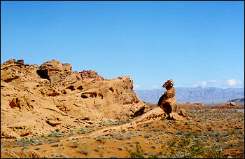
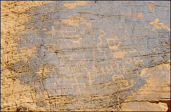
Nearby Locations of Interest - Valley of Fire State Park |
|
Valley of Fire State Park, near the northern tip of Lake Mead, is home to some spectacular scenery where a range of iron-rich red mountains peek out of normally drab valleys. It also contains very well-preserved Indian petroglyphs in many easily accesible locations. It is Nevada's oldest state park and an easy day-trip from Las Vegas.
The trail to 'Mouse's Tank' is disappointing except for a small number of petroglyphs. A better bet is to spend that time touring the rest of the park by car. The visitor's center is a welcome sight so far from civilization and gives a nice geologic and archeologic history of the park. If you are arriving via I-15, stop at the convenience store in Moapa for an interesting (if less than genuine) Indian experience and a Gatorade.
|
|
Nearby Locations of Interest - Hoover Dam |
|
We've all heard about and seen pictures of Hoover Dam, and it certainly is impressive to see it in person. The problem with visiting is that there are plenty of Americans also waiting to see this engineering marvel, and it seems like a large majority will arrive on the same day you do. Crowds, even in the early spring, are too large even for the newly-constructed visitors center.
There are several different tours, and the basic tour will take you to all the impressive parts of the dam. A more expensive, and longer, hard-hat tour is available for the more adventurous. You will probably stand in line for upwards of an hour if you go while the dam is moderately busy.
A visit to Hoover can be memorable, but it requires a good deal of patience any time except the off-season (winter).
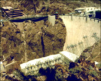
Image by United States Department of the Interior
|
|
Appendices - Other Resources |
|
Here is a list of resources - online and off - which be helpful for further research into Area 51.
Desertsecrets.com
This site is contains many great visuals and pieces information about Groom Lake and the areas around it, including government documents and 'trip reports' from various vantage points around the Nellis Range. Don't miss the 'Other Photos' section, which contains some astounding photographs of Groom Lake before it was top-secret.
Area 51 Research Center
As described in Area 51 & Related Sites of Interest, the Research Center has an excellent web site. See Calendar dates for Air Force and other Area 51-related ctivities, as well as an excellent timeline of the history of military involvement in the region.
The Groom Lake Desert Rat
A must-read (but no longer published) newsletter by Glenn Campbell, a software engineer-turned-Area 51 expert. He records in detail the goings-on at the base and everywhere else as the frenzy of the mid-90s ran its course. Read about equipment seizures and detainments by the Cammo dudes, and Campbell's rise to fame.
"Area 51" Viewer's Guide
As mentioned in Area 51 Viewing directions, this is a truly comprehensive and authoritative guide to Area 51, Nellis, and all related places. It was compiled by Campbell over the period he was writing the 'Desert Rat'. If you're serious about visiting the area, or even if you're just looking for a good read, look no further. The link is the only place on the web where the Viewer's Guide is available - don't be scared off because it isn't Amazon.com, we had no problems ordering.
Area 51 @ Aliens On Earth
Again, don't let the title fool you. This is the last Campbell-associated link; it is an online version of the above two resources, containing a great deal of information and many photos of the facility and surrounding sites.
Bluefire
This is a website created by a man who spent many years poking around the desert, much like Campbell, in search of adventure just outside the 'restricted' line. There are many entertaining accounts of climbs of mountains in the area, as well as hunts for various other items (like a crashed SR-71).
|
|
|
May 2001 - For Technical Communication, English 271
Last updated: 8 May 2001
|
|

